Quick answer: the Perranporth to St Agnes stretch of the South West Coast Path is about four miles of the most storied clifftop in Cornwall — smugglers’ caverns under Droskyn Point, a headland honeycombed by tin workings at Cligga, one of the last places in the world still streaming Cornish tin at Blue Hills, and a ruined harbour at Trevaunance Cove — with an optional two-mile extension past St Agnes Head to Wheal Coates, the most photographed engine house in the county. Moderate effort, one steep valley, endless history underfoot. The route, the stories and the practicalities — below.
Some walks are scenery; this one is a story you walk through. Between Perranporth and St Agnes the cliffs are stained orange and green with minerals, pierced by mine adits, and undercut by caverns that real smugglers really used — the ground truth behind two of our history guides, the pirates of Cornwall and Cornwall’s tin mining heritage. Fair warning before we set off: I haven’t walked the full path yet. I’ve stood at the foot of it, on Perranporth beach among the rock pools, looking up at a barred tunnel mouth in the cliff — and this article is the homework that look made me do. It’s written from research and from the maps, it’s honest about that, and the walk is now firmly on my list.
Table of Contents
- The walk at a glance
- Droskyn Point: the smugglers’ end
- Cligga Head: the honeycombed cliff
- Trevellas Porth and Blue Hills Tin
- Trevaunance Cove and St Agnes
- The extension: St Agnes Head, Wheal Coates and Chapel Porth
- Practicalities and safety
- Personal insights and experiences
- FAQ
- References and resources
The walk at a glance
- Route: Perranporth (Droskyn Point) to St Agnes (Trevaunance Cove) on the South West Coast Path
- Distance: roughly 3.5–4 miles one way; allow 2–2.5 hours with stops (you will stop)
- Effort: moderate — clifftop walking with one properly steep drop and climb at Trevellas Coombe
- Extension: about 2 further miles past St Agnes Head to Wheal Coates and Chapel Porth
- Start parking: Droskyn car park above the west end of Perranporth beach; finish at Trevaunance Cove or Chapel Porth (National Trust)
- Getting back: buses link St Agnes and Perranporth along the coast road — check Transport for Cornwall for times — or retrace your steps with the views reversed, which is no punishment
Droskyn Point: the smugglers’ end
The walk starts on top of the story. Beneath Droskyn Point, at the western end of Perranporth beach, sea caverns big enough to hold several rowing boats sit under eighty feet of cliff, and in the 1700s a shaft ran from the cavern roof to the clifftop so that contraband — brandy, tea, silk, run in fast from France — could be hauled up by rope and pulley to waiting mules. In 1780 the respectable men of the parish, the vicar among them, formed a syndicate and bought a ship, the Cherbourg, to trade with France directly. From the beach below you can see barred openings in the cliff face: mine adits by origin, smugglers’ infrastructure by opportunity, and irresistible to every child who has ever decided a cave must belong to pirates. At Perranporth, the children are right. The full story is in our pirates guide; up here you simply walk over the top of it, past the clifftop sundial, and let the coast pull you south-west.
Cligga Head: the honeycombed cliff
A mile on, Cligga Head is what a cliff looks like after centuries of being mined for tin and tungsten: stained rust-orange and copper-green, riddled with tunnels, the ground above it pocked with fenced shafts and the concrete ghosts of later works. It is also, unexpectedly, an aviation site — the flat clifftop behind was RAF Perranporth, a wartime fighter airfield, and parts of its runways survive among the gorse. Stay on the path here and keep dogs close: the fences around old workings are not decorative. The reward is the view — on a clear day the whole run of coast to St Agnes Head, layered headland behind headland, with the sea working away at cliffs that men once worked from the inside.
Trevellas Porth and Blue Hills Tin
The path then drops — steeply, this is the walk’s one real climb-back — into Trevellas Coombe, a valley that looks like a museum left out in the weather: ruined engine houses, waste tips softened by heather, and a rocky cove at the bottom where miners once landed coal. And here is the walk’s quiet marvel: at Blue Hills, in the valley floor, a family still produces tin — streaming it from the valley’s gravels and casting it into jewellery and ingots, one of the last places anywhere keeping an unbroken Cornish craft alive. They open to visitors in season (check ahead), and watching molten tin poured in the valley where tinners worked for centuries is as close as you can get to our mining guide happening in front of you.
Trevaunance Cove and St Agnes
Over the next headland the path lands you at Trevaunance Cove, St Agnes’ beach — sand at low tide, surf school, proper pub above the slipway — where the stub of ruined walls in the corner is all that remains of St Agnes harbour, rebuilt five times against the Atlantic and finally surrendered to it in the early twentieth century. The village up the hill is one of Cornwall’s great mining settlements, its terrace of miners’ cottages stepping downhill so distinctively that locals call the row Stippy Stappy. St Agnes also keeps one of Cornwall’s best giant-legends — Bolster, said to stride between hilltops here, remembered every spring in the village’s Bolster Day pageant; our storytelling guide has more of that tradition. Food, a pint, a bus home — or keep walking.
The extension: St Agnes Head, Wheal Coates and Chapel Porth
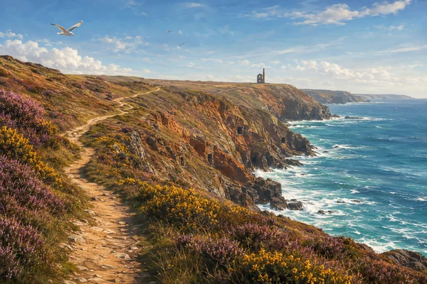
With another hour in your legs, carry on around St Agnes Head — nesting seabirds, heather and gorse in season, and a horizon that goes on forever — to the county’s most famous industrial ruin: Wheal Coates, whose Towanroath engine house stands alone on the cliff edge above a turquoise sea. It is the image on half the postcards in Cornwall, and no photograph quite prepares you for how precarious the real thing looks. This whole coast is what people mean when they say Poldark country — though the series’ actual mine scenes were filmed further west at Botallack — and the path drops finally to Chapel Porth, a National Trust cove with a café whose hazelnut-and-honeycomb “hedgehog” ice cream has a fame entirely out of proportion to the size of the beach. From there, lanes and paths loop back up to St Agnes village.
Practicalities and safety
- Stay on the path. This is mined ground: shafts are capped or fenced, but wandering off-piste among old workings is genuinely dangerous.
- The Trevellas descent and climb are steep — poles help if knees complain; boots or grippy trainers, not sandals.
- Exposure: almost the whole route is open clifftop — glorious in sun, serious in wind and rain. Check the forecast (our weather guide explains how fast it changes) and give storms the respect they demand.
- Facilities: everything at Perranporth, pub and café at Trevaunance Cove, café at Chapel Porth; nothing in between.
- Dogs: fine on the path; seasonal daytime bans apply on the beaches in summer.
- Combine it: the Perranporth end pairs perfectly with a low-tide session in the rock pools — or build it into a Newquay-area family day.
Personal insights and experiences
I’ll tell you exactly where this article came from. Last August, on a family day at Perranporth, my son and I worked the rock pools under the western cliffs at low tide — and the longer we stayed, the more the cliffs themselves took over the conversation. Mineral stains in colours rock has no business being, dark square openings, and higher up a barred hole like a window, which the children immediately and unanimously declared to be smugglers’. I looked it up that evening expecting to let them down gently, and found out they were right — the caverns, the shaft, the vicar’s syndicate, the lot. That’s the moment this walk went on my list: I have stood at the bottom of it and felt the pull of what’s on top. Since we got home I’ve traced every yard of the route on Google Maps and Google Earth — hanging over Cligga’s workings and the Trevellas valley like a gull with a research habit — and I’ve already told the family: we’re doing this one. I haven’t walked it yet, and I won’t pretend otherwise — what you’ve read here is my homework, done properly, from the path guides and the histories. When I do walk it — and the plan is boots, a flask, and a tide-timed finish back at the Perranporth pools — I’ll come back and tell you how the real thing compares. If you get there before me, I’m genuinely envious.
FAQ
Q: How long is the Perranporth to St Agnes coast path walk?
A: About 3.5–4 miles one way, taking 2–2.5 hours at an exploring pace. Adding St Agnes Head, Wheal Coates and Chapel Porth makes it roughly 6 miles.
Q: How hard is the walk?
A: Moderate. Mostly rolling clifftop with one steep valley (Trevellas Coombe) to descend and climb. Proper footwear and weather awareness are the only requirements.
Q: Can you see the smugglers’ caves at Perranporth?
A: From the beach at low tide you can see the barred adits and cave mouths under Droskyn Point; the caverns themselves are not accessible. The story is real — an eighteenth-century syndicate, vicar included, ran contraband through them.
Q: Is Wheal Coates the Poldark mine?
A: It’s the engine house on the postcards and this is the landscape people mean by “Poldark country”, but the series filmed its mine scenes at Botallack, further west. Wheal Coates needs no help from television.
Q: Which direction should you walk it?
A: Perranporth to St Agnes puts the best finale (Trevaunance Cove, or Wheal Coates on the extension) ahead of you and a pub at the end. Walking it in reverse works fine — buses connect the two.
References and resources
- South West Coast Path Association — official route guidance: www.southwestcoastpath.org.uk
- Blue Hills Tin — visiting the tin streams: www.bluehillstin.com
- National Trust — Wheal Coates and Chapel Porth: www.nationaltrust.org.uk
- Transport for Cornwall — bus times: www.transportforcornwall.co.uk
- Met Office — coastal forecasts: www.metoffice.gov.uk